Project leader & contact person: Dr. Lael Parrott, Associate Professor & Director, BRAES Insitute, The University of British Columbia (UBC), Okanagan Campus, Phone: 250 807 8122 Email: lael.parrott@ubc.ca
Participating researchers: Catherine Kyle, Graduate research assistant, UBC; Valerie Hayot-Sasson, Undergraduate research assistant, McGill University; Charles Bouchard, Undergraduate research assistant, McGill University; Dr. Jeffrey Cardille, Associate Professor, McGill University
Objective: The objective of this work was to identify a terrestrial network of patches and corridors whose conservation or restoration may contribute to maintaining habitat connectivity for a broad range of species in the Okanagan Valley.
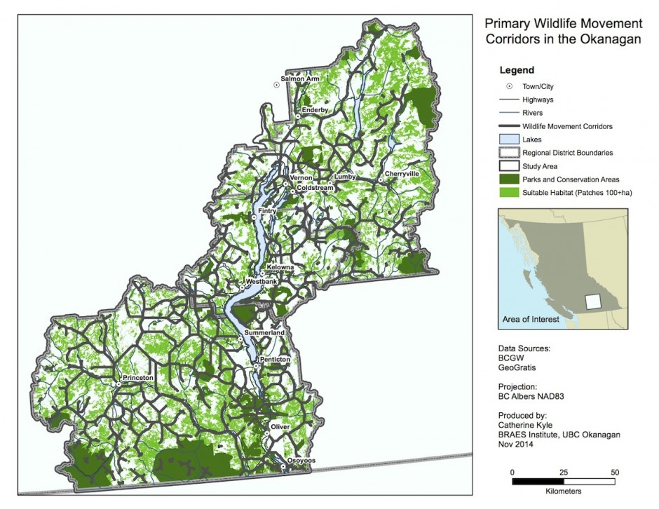
Map 1: Locations of large patches of natural vegetation and key wildlife movement corridors (dark brown lines) in the Okanagan Valley. While not species specific, these corridors represent the routes that the majority of species might use to transit the valley. This map builds on analyses done for the Okanagan Biodiversity Strategy (OCCP & SOSCP, 2014).
Introduction
Conversion of natural habitats for human land use in the Okanagan Valley is having significant impacts on biodiversity. At approximately 8000 km2, the Okanagan represents only 0.8% of British Columbia’s land area, yet it contains over 30% of the red listed species in the province and 46% of the blue listed species (BC Ministry of Environment, 1998). In addition to habitat loss, fragmentation of existing habitats is a key area of concern. Many species require large, contiguous tracts of habitat in order to survive. Other species need to transit through the valley and are having to navigate through subdivisions, agricultural fields, and across highways. For some species, these human land uses serve as barriers to movement, effectively isolating populations in small pockets of remnant habitat. We humans value continuous transportation corridors and other species do too!
Map 1 (above) shows where key wildlife corridors are located in the Okanagan Valley. These are areas where we should work to keep natural habitat connected to facilitate species movement either through conservation or restoration initiatives. Maps 2 & 3 (below) show details for the North and Central and South Okanagan Regional Districts. Maps like these can be used to help inform environmental land use policy and planning decisions in the valley.
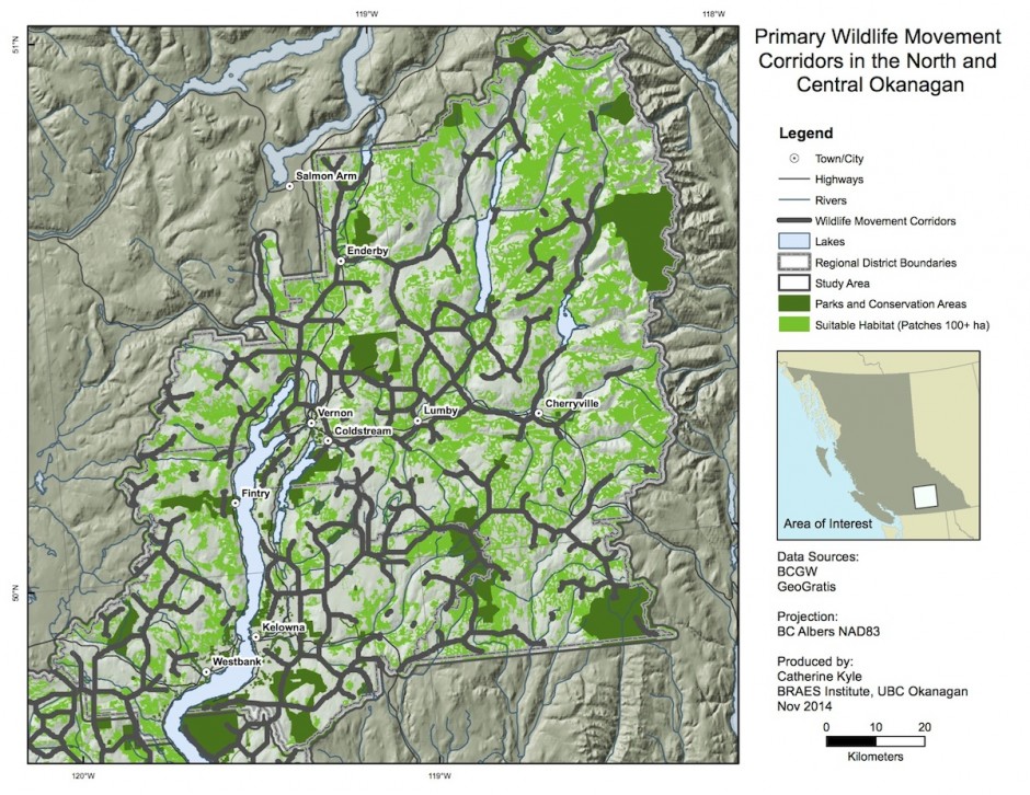
Map 2: Locations of large patches of natural vegetation and key wildlife movement corridors (dark brown lines) in the North and Central Okanagan.
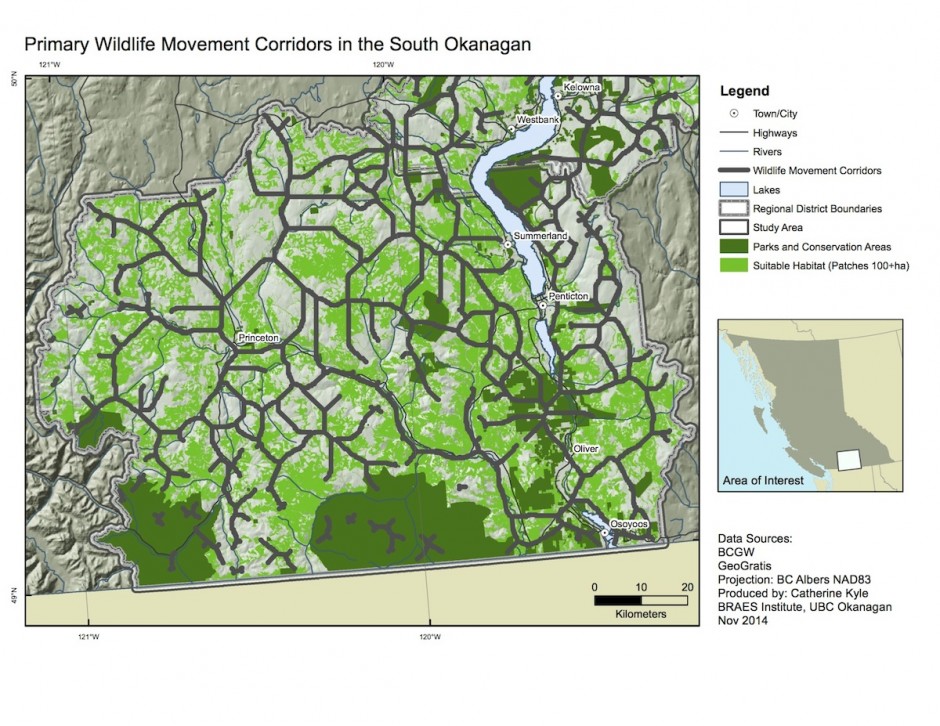
Map 3: Locations of large patches of natural vegetation and key wildlife movement corridors (dark brown lines) in the South Okanagan.
Methods: The analyses built directly upon the mapping products developed to support the Biodiversity Conservation Strategy (BCS) for the Okanagan Region (OCCP & SOSCP, 2014). The study area included the land within the boundaries of the North, Central and South Okanagan Regional Districts.
Identification of suitable natural habitat
Suitable natural habitat was defined as any land parcel in the study area having a relative biodiversity ranking of moderate, high or very high, according to the methods established for the BCS (Caslys Consulting, 2011 & 2013). These methods assess each parcel on the landscape using a weighting function that combines the parcel’s conservation ranking, the patch size, and its distance from linear disturbance features (roads, power lines, etc.). Additional weight is given to antelope brush, wetlands, and riparian zones. Parcels are then classified based on these weightings into very low, low, moderate, high and very high relative biodiversity. These methods are not species specific, but provide a consistent, overall ranking of the relative biodiversity of parcels across the region.
We selected parcels of contiguous suitable natural habitat of 100 hectares or greater. These are shown in light green on the attached maps. Consistent with Environment Canada recommendations (Environment Canada, 2013), these large parcels of suitable natural habitat can be considered the most important habitat reservoirs on the landscape that would support a majority of native species. Conservation efforts should therefore be focused on protecting large parcels in the landscape as well as maintaining their connectivity so as to retain biodiversity and associated ecosystem services at the landscape scale. In addition, linking smaller parcels of high quality remnant habitat to these larger parcels should increase the conservation effectiveness of the smaller parcels.
Locating habitat corridors and linkages
This work builds on the data from the BCS Habitat Connectivity maps created for the North, Central and South Okanagan (Caslys Consulting Inc., 2011 & 2013). In these maps, a “connectivity” value is assigned to each parcel of land based on a number of assumptions regarding the ability of a generic species to traverse it (for example, connectivity is assumed to be higher in close proximity to water and on gentle slopes; high elevation, rugged, steep slopes may have lower connectivity, and urban areas are connectivity barriers). Parcels are then classified into the categories: barrier, low, moderate or high connectivity depending on their connectivity value. The BCS Habitat Connectivity maps thus depict the relative ease with which species can move through different parts of the landscape, without identifying habitat corridors per se.
The unclassified values on the BCS Habitat Connectivity map were used to establish resistances to wildlife movement on the landscape. The Circuitscape program (McRae, Hall, Beier, & Theobald, 2012) was then applied to the resistances to identify “least cost” movement paths for wildlife through the study area. Further analysis of the Circuitscape output resulted in a network of lines on the map representing the most likely routes for species movement (methods described in Parrott et al, unpublished). Routes with a high volume of flow were identified as habitat connectivity corridors. Maps 1-3 show suitable natural habitat patches greater than 100 hectares the Okanagan Valley with regional habitat connectivity corridors shown in brown. These corridors represent places where species would be the most likely to transit in the landscape, based on the assumptions inherent to the BCS habitat connectivity maps. These key movement corridors often occur in locations where topography or land cover and land use restrict the number of options that species have for movement. They are thus critical connections between habitats in the valley. Additional analyses of the Circuitscape output (not shown) also allowed for the identification of secondary and tertiary linkages present in some areas.
Results
Maps 1-3 show the importance of certain low elevation valley bottoms and riparian areas in maintaining ecological connectivity. The results also identify locations of cross-elevation and upper elevation corridors that are important for maintaining north-south and east-west movement routes for wildlife. It should be noted that the BCS Habitat Connectivity rankings analysis is not species specific and therefore suggested locations for corridors and linkages may not be appropriate for all species types. They do, however, indicate where the vast majority of species are likely to travel on the landscape.
Further work is being undertaken in the Complex Environmental Systems Lab to model and analyze landscape connectivity for specific focal species, particularly those whose movement patterns may not be well represented by the assumptions made in the BCS habitat connectivity mapping (e.g., bighorn sheep). The species-specific results will enable further refinement of the valley-wide wildlife corridor maps presented here.
References
Caslys Consulting Inc. 2011. A biodiversity conservation analysis for the South Okanagan-Similkameen Region. Part 1, Volume 1 of the Keeping Nature in our Future Series. Report submitted to the South Okanagan-Similkameen Conservation Program (SOSCP), September 2011. 79 pages.
Caslys Consulting Inc. 2013. A biodiversity conservation analysis for the North and Central Okanagan Region. Part 2, Volume 1 of the Keeping Nature in our Future Series. Report submitted to the Okanagan Collaborative Conservation Program (OCCP), January 2013. 98 pages.
Environment Canada. 2013. How Much Habitat is Enough? Third Edition. 130 pages.
McRae, B. H., Hall, S. A., Beier, P., & Theobald, D. M. 2012. Where to restore ecological connectivity? Detecting barriers and quantifying restoration benefits. PloS One, 7(12), e52604.
OCCP & SOSCP. 2014. A biodiversity conservation strategy for the Okanagan Region. Part 2, Volume 2 of the Keeping Nature in our Future Series. April 2014.
Parrott, L., Kyle, K., Hayot-Sasson, V., Bouchard, C., Pelletier, D. and Cardille, J. Planning for ecological connectivity in a multifunctional regional landscape. Manuscript in preparation.

